Last updated 6/26/25 4:00 pm
WMA, PFA, & Hatchery Closures
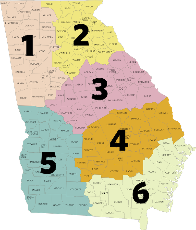
Region 1
For alerts & warnings on Chattahoochee-Oconee National Forest, please visit https://www.fs.usda.gov/r08/chattahoochee-oconee/alerts for the most current information. Review the gate openings and hunting season information for the 24-25 hunting season.
*Please note that the stream near Holly Creek Bridge is undergoing maintenance but should have minimal impact on traffic.
Cohutta WMA
Updated 4/28/25
Forest Service has temporarily closed Rocky Flats (FS Road 630D) due to road damage.
Paulding Forest WMA
Updated 6/26/25
Blue Car Body Rd. is closed to vehicle traffic June 6 - August 14, 2025 for road maintenance and repair.
Region 2
For alerts & warnings on Chattahoochee-Oconee National Forest (Blue Ridge, Chattahoochee, Chestatee, Cooper's Creek, Lake Russell, Redlands, Swallow Creek, and Warwoman), please visit https://www.fs.usda.gov/r08/chattahoochee-oconee/alerts for the most current information.
Dawson Forest WMA
Updated 6/26/25
The Shoal Creek Bridge is Closed.
Updated 6/2/25
All roads on the City of Atlanta Tract are closed. The trailhead parking lot is still open.
Redlands WMA
Updated 4/1/25
The upper Redlands Check Station dove field will be open for turkey season. The gate will remain closed, but hunters may hunt that field.
Region 3
Cedar Creek WMA
Updated 4/11/25
FSR 1048 is currently closed at both ends—with signage posted at the north entrance on Bradley Road and at the southern intersection with FSR 1048A. Rock Creek Hunt Camp is also closed, as it is being used as a turnaround point by contractors. FSR 1048 will remain impassable for approximately the next three months.
Cybel WMA/Marben PFA
Updated 10/16/23
Lake Margery at Marben PFA is currently closed to all access (fishing/boating). The lake has been drained for maintenance. When complete, the lake will be allowed to refill. Once water is at appropriate levels, fish stockings can occur. Potential re-opening date for this lake is Spring 2025.
McDuffie PFA
Updated 4/7/25
The PFA is open! We are continuing to make improvements and updates post-Hurricane Helene. The main office is open. The bath house near Clubhouse Lake is open. The campground is under renovation, so it is currently closed. There is a port-a-potty, but no bath house available, in the Willow Boat Launch area.
Region 6
Ocmulgee PFA
Updated 6/17/25
Bear with us! Ocmulgee PFA is undergoing maintenance work, including preparing for some upcoming paving (which will affect access to the boat ramp). Currently, the power to the lights at the boat ramp is off. We will continue to post updates as the work progresses.
Region 6
Grand Bay WMA
Updated 5/15/25
Starting Monday, May 19, the main access road to Grand Bay WMA, 4514 Knight Academy Road, will be temporarily closed due to a timber harvest occurring on and near the WMA. For the safety of our visitors, the road will remain closed for the duration of the logging operation.
Updated 10/22/24
The WMA is open. The boardwalk, Education Center and access to those facilities will remain closed until hazardous trees are removed and structures repaired. The roads accessing the check station and the main portion of the state-owned section of Grand Bay WMA have been cleared. Users should use caution when in the woods as hazardous trees may still exist.
Updated 7/9/21
Due to military training needs on the federally owned portion (Highway 221 tract) of Grand Bay WMA, that section will be closed to public access periodically.
The automatic gate to the Grand Bay WMA boardwalk and lookout tower is open from 6 a.m.–8 p.m. daily and during classes at the Education Center. Anyone in that area after 8 p.m. may be locked in and is subject to being ticketed by the GADNR Law Enforcement Division.
Little Satilla WMA
Updated 8/9/24
As of Aug. 1, 2024, the southwestern border of the Little Satilla Wildlife Management Area (WMA) has changed. The landowner has removed approximately 1,109 acres in Pierce County along the Little Satilla River from the WMA agreement with the state. This change takes place near GA Highway 32, Lilac Rd, and Knight Rd. Gates have been installed at the boundary lines and off-property roads have been removed from the online map. See the online map for updated WMA boundary lines.
Sapelo Island WMA
Updated 3/27/25
Hunters drawn for Sapelo Island deer quota hunts must arrange for their own transportation to the island via private boat. Reference the private charters list to arrange transportation. The Georgia Department of Natural Resources does not endorse any one business for use.
Townsend WMA
Updated 1/17/24
Roads accessing portions of Townsend WMA may be flooded by the Altamaha River during times of high water. WMA users should use caution and make appropriate plans anytime the Altamaha River level at the Doctortown gauge is above 7ft. Check the National Weather Service for up to date levels.
Shooting Ranges
No Closures at This Time
Education Centers
Charlie Elliot Wildlife Center
Updated 6/5/25
The Red Trail Loop is currently impassable due to construction at the dam. The loop will remain closed to through-hikers until September.
Updated 10/16/23
Lake Margery at Marben PFA is currently closed to all access (fishing/boating). The lake has been drained for maintenance. When complete, the lake will be allowed to refill. Once water is at appropriate levels, fish stockings can occur. Potential re-opening date for this lake is Spring 2025.
Boat Ramps
If designated parking areas on boat ramps, shooting ranges, trail heads or similar areas are full, the area has reached capacity. Do not park outside designated spaces. Do not park in any area not designated for legal parking. Normal rules for parking on WMAs apply—see hunting regulations on page 41.
**Contact region offices should you want to check ramp conditions ahead of time.
Closures
Brewton’s Bridge Landing on the Canoochee River (Evans County)
Posted 8/22/24
Effective immediately, Brewton’s Bridge Landing on the Canoochee River, located adjacent to the State Road 169 Bridge, is temporarily closed. Closure is due to recent storm-related flooding that impacted the parking lot, creating hazardous conditions. A reopening date has not yet been determined. If needed, anglers and boaters can access the Canoochee River downstream at the US 280 ramp (Evans County).
Brewton’s Bridge Landing at SR 169 on the Canoochee River (Evans County)
Updated 10/22/24
The boat ramp is currently closed due to storm damage.
Champney River Park Boat Ramp off US Hwy 17 (McIntosh County)
Posted 1/2/2025
The James Allen Williamson Champney River Park and boat ramp south of downtown Darien off U.S. Highway 17 will close for renovations on January 28, 2025. The closure is expected to last approximately six months as the facility undergoes significant upgrades and repairs. For more info, visit Coastalgadnr.org/champney-river-park-boat-ramp-close-renovations. Visitors are encouraged to plan ahead and explore alternative boat ramps in the area during the closure. A comprehensive list of coastal boat ramps can be found at CoastalGaDNR.org/AllBoatRamps.
Ogeechee River Boat Ramp SR4/US1 (Jefferson County)
Updated 8/10/23
The Ogeechee River Boat Ramp located in Jefferson County at Georgia State Route 4/US Highway 1 is closed due to bridge replacement construction operations. A heavy crane will be placed at the ramp site to facilitate the movement of materials for the bridge project. A re-opening date for the ramp is yet to be determined. Alternative boat ramp locations on the Ogeechee River are as follows: upstream at State Hwy 88 (Jefferson County), and downstream at State Hwy 78 (Jefferson County).
Cautions
Hwy. 83 Boat Ramp (Jasper County, Ocmulgee River)
Updated 8/9/24
Caution When Using: Anglers and boaters using the Hwy. 83 Boat Ramp (Jasper County, Ocmulgee River - about 15 miles south of Monticello) should know that the boat ramp is open to the public. However, caution is advised due to ongoing logging and clearing operations in preparation of upcoming ramp replacement and highway bridge rebuilding. There will be heavy equipment moving nearby with logging trucks entering and exiting the property. Further information will be posted as needed.
Punks Landing Boat Ramp on the Flint River (Mitchell County)
Updated 4/9/25
Anglers and boaters planning to use the Punks Landing boat ramp and parking area on the Flint River (Mitchell County) are advised to use caution while at this location. A large sinkhole has developed and appears to be expanding. A cautionary barricade is being installed for public safety. Authorized persons are actively surveilling the feature to determine future developments and devise a course of corrective action. Until such time that it can be repaired, the public is advised to use caution while approaching or using the area. Future updates will be provided as available.


