


Last Updated 6/4/2026 at 11:45 am
WMA, PFA, & Hatchery Closures
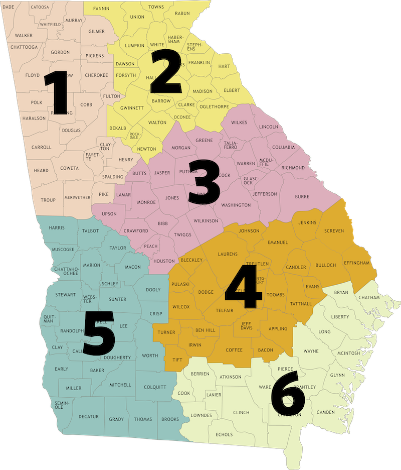
Region 1
For alerts & warnings on Chattahoochee-Oconee National Forest, please visit https://www.fs.usda.gov/r08/chattahoochee-oconee/alerts for the most current information. Review the gate openings and hunting season information for the 25-26 hunting season.
*Please note that the stream near Holly Creek Bridge is undergoing maintenance but should have minimal impact on traffic.
Cohutta WMA
Updated 7/23/25
The Hickory Ridge and Rough Ridge Trails are temporarily closed due to unsafe conditions. These closures, issued by the U.S. Forest Service, help ensure visitor safety following damage from past wildfires, drought, and severe weather events.
View trail closure map (PDF, 900 KB).
John's Mountain WMA
Updated 4/10/26
Roads 995E and 955B are temporarily closed.
Rich Mountain WMA
Updated 5/26/26
The handicap road will be closed to all usage for the remainder of the summer until August 15th.
Region 2
For alerts & warnings on Chattahoochee-Oconee National Forest (Blue Ridge, Chattahoochee, Chestatee, Cooper's Creek, Lake Russell, Redlands, Swallow Creek, and Warwoman), please visit https://www.fs.usda.gov/r08/chattahoochee-oconee/alerts for the most current information.
Dawson Forest WMA
Updated 4/1/26
City of Atlanta Tract: Blue Trail is temporarily closed beyond the Orange and Pink Trail turnoffs until further notice for timber harvesting.
Updated 2/5/26
City of Atlanta Tract: A few roads may be closed to ongoing Winter Storm cleanup. Please check with the Gainesville office (770-535-5700) for updates.
Redlands WMA
Posted 4/23/26; Updated 6/4/26
The US Forest Service has temporarily closed the Swords Parking Lot for repaving (closes May 21, reopens early June).
Region 3
Cedar Creek WMA
Updated 4/11/25
FSR 1048 is currently closed at both ends—with signage posted at the north entrance on Bradley Road and at the southern intersection with FSR 1048A. Rock Creek Hunt Camp is also closed, as it is being used as a turnaround point by contractors. FSR 1048 will remain impassable for approximately the next three months.
Cybel WMA/Marben PFA
Updated 10/16/23
Lake Margery at Marben PFA is currently closed to all access (fishing/boating). The lake has been drained for maintenance. When complete, the lake will be allowed to refill. Once water is at appropriate levels, fish stockings can occur. Potential re-opening date for this lake is TBD.
McDuffie PFA
Updated 4/7/25
The PFA is open! We are continuing to make improvements and updates post-Hurricane Helene. The main office is open. The bath house near Clubhouse Lake is open. The campground is under renovation, so it is currently closed. There is a port-a-potty, but no bath house available, in the Willow Boat Launch area.
Region 6
Grand Bay WMA
Updated 7/9/21
Due to military training needs on the federally owned portion (Highway 221 tract) of Grand Bay WMA, that section will be closed to public access periodically.
The automatic gate to the Grand Bay WMA boardwalk and lookout tower is open from 6 a.m.–8 p.m. daily and during classes at the Education Center. Anyone in that area after 8 p.m. may be locked in and is subject to being ticketed by the GADNR Law Enforcement Division.
Sapelo Island WMA
Updated 3/27/25
Hunters drawn for Sapelo Island deer quota hunts must arrange for their own transportation to the island via private boat. Reference the private charters list to arrange transportation. The Georgia Department of Natural Resources does not endorse any one business for use.
Townsend WMA
Updated 1/17/24
Roads accessing portions of Townsend WMA may be flooded by the Altamaha River during times of high water. WMA users should use caution and make appropriate plans anytime the Altamaha River level at the Doctortown gauge is above 7ft. Check the NOAA flood gauge for up to date levels.
Shooting Ranges
Wilson Shoals Shooting Range
Posted 2/12/26
The Wilson Shoals Shooting Range is temporarily close from April 1- Sept. 30, 2026, for renovations. These renovations and improvements will include adding a Kongsberg electronic target system and steel targets, extending the rifle range to 100 yards and lead mitigation.
Education Centers
Charlie Elliot Wildlife Center
Updated 10/16/23
Lake Margery at Marben PFA is currently closed to all access (fishing/boating). The lake has been drained for maintenance. When complete, the lake will be allowed to refill. Once water is at appropriate levels, fish stockings can occur. Potential re-opening date for this lake is TBD.
Boat Ramps
If designated parking areas on boat ramps, shooting ranges, trail heads or similar areas are full, the area has reached capacity. Do not park outside designated spaces. Do not park in any area not designated for legal parking. Normal rules for parking on WMAs apply—see hunting regulations on page 41.
**Contact region offices should you want to check ramp conditions ahead of time.
Closures
Swords Landing on Lake Oconee
Posted 4/29/26; Updated 6/4/26
The US Forest Service has temporarily closed the Swords Parking Lot for repaving (closes May 21, reopens early June).
Ogeechee River Boat Ramp SR4/US1 (Jefferson County)
Updated 8/10/23
The Ogeechee River Boat Ramp located in Jefferson County at Georgia State Route 4/US Highway 1 is closed due to bridge replacement construction operations. A heavy crane will be placed at the ramp site to facilitate the movement of materials for the bridge project. A re-opening date for the ramp is yet to be determined. Alternative boat ramp locations on the Ogeechee River are as follows: upstream at State Hwy 88 (Jefferson County), and downstream at State Hwy 78 (Jefferson County).
Cautions
Hwy. 83 Boat Ramp (Jasper County, Ocmulgee River)
Updated 10/8/25
Caution When Using: Anglers and boaters using the Hwy. 83 Boat Ramp (Jasper County, Ocmulgee River – about 15 miles south of Monticello) should know that the boat ramp is open to the public. However, caution is advised due to ongoing bridge demolition and construction in preparation for future project completion. Heavy equipment will be entering and exiting the property for the accomplishment of asphalting and future bridge demolition. Further information will be posted as available.